
Key Takeaways:
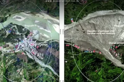
- ISRO’s Cartosat-2S satellites captured severe damage in Dharali, Uttarakhand, after a flash flood on August 5.
- Images reveal widened river channels, destroyed buildings, and a 20-hectare debris deposit at the Bhagirathi-Kheer Gad confluence.
- IMD denies cloudburst claims, stating only 27mm rainfall—far less than needed for such devastation.
ISRO Exposes Uttarkashi Flash Flood Destruction Through Satellite Imagery
The Indian Space Research Organisation (ISRO) has unveiled startling satellite images of the catastrophic flash flood that struck Dharali village in Uttarkashi, Uttarakhand, on August 5. The National Remote Sensing Centre (NRSC) utilized high-resolution data from India’s Cartosat-2S satellites to assess the devastation, revealing widened river channels, destroyed infrastructure, and alarming debris deposits.
A Village Buried Under Mud & Debris
The flood, triggered by heavy rainfall, unleashed debris-laden torrents that swept through Dharali and Harsil, washing away homes, bridges, and roads while claiming multiple lives. ISRO’s analysis highlights a fan-shaped sediment deposit spanning 20 hectares at the confluence of the Kheer Gad and Bhagirathi rivers—evidence of the flood’s ferocity.
“Several buildings in the flood zone have either partially or completely vanished, likely submerged or carried away by the violent mudflow,” NRSC stated. The images also show dramatic changes in river morphology, raising concerns about long-term environmental impact.
Search, Rescue & the Cloudburst Controversy
ISRO emphasized that the satellite data will aid rescue teams in locating stranded survivors and reconnecting isolated areas. However, the disaster has reignited debates on Himalayan fragility, with scientists investigating the exact trigger of the flood.
Contradicting initial assumptions, the India Meteorological Department (IMD) dismissed cloudburst claims, noting that Uttarkashi recorded only 27mm of rainfall—far below the threshold needed for such a disaster. This discrepancy has left experts puzzled, prompting calls for deeper geological studies.
As Uttarakhand grapples with the aftermath, ISRO’s findings serve as a grim reminder of the Himalayas’ growing vulnerability to extreme weather events.


Leave a Reply