
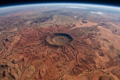
When viewing Earth from the silent, cold vacuum of space, the planet reveals patterns and structures that are invisible to the naked eye at ground level. Recently, NASA’s latest high-resolution satellite imagery captured a phenomenon that has sent waves through both the scientific community and the public imagination: a massive, arachnid-like structure sprawling across the arid expanse of the Australian Outback. Known colloquially as the ‘Giant Spider’ due to its radial symmetry and spindly, leg-like ridges, this formation is not a biological entity but a breathtaking geological relic of a cataclysmic event that occurred millions of years ago. The imagery, provided by the Landsat 9 satellite, offers an unprecedented look at the Tnorala (Gosses Bluff) impact crater and its surrounding environment, highlighting the intricate interplay between celestial impact and eons of terrestrial erosion. This discovery serves as a potent reminder of Earth’s dynamic history, where the scars of the past are etched into the landscape, waiting for the right technology to unveil their full glory. As we delve into the specifics of this ‘spider,’ we find a narrative of cosmic violence, geological resilience, and the sheer beauty of natural symmetry that characterizes our home planet.
The Cosmic Architect: Origins of the Spider Formation
The ‘Giant Spider’ of Australia is primarily represented by the Tnorala or Gosses Bluff impact structure, located in the MacDonnell Ranges of the Northern Territory. This geological marvel was formed approximately 142 million years ago during the Early Cretaceous period. A massive comet or asteroid, estimated to be about 600 meters in diameter, slammed into the Earth’s surface with a force equivalent to tens of thousands of nuclear explosions. The initial impact created a crater nearly 22 kilometers wide, but the passage of time and the relentless forces of wind and water have significantly altered its appearance. What remains today is a central ring of hills about 5 kilometers in diameter, which forms the ‘body’ of the spider, while the radiating drainage patterns and eroded ridges create the illusion of long, sprawling legs extending into the surrounding desert floor.
Geologically, the formation is a textbook example of a complex impact crater. When the bolide struck, it compressed the target rocks to extreme pressures, followed by a rapid decompression that caused the center of the crater to rebound upward, much like a drop of water splashing in a pool. This central uplift brought older, harder rocks from deep within the Earth’s crust to the surface. Over millions of years, the softer surrounding sediments were stripped away by erosion, leaving the durable, quartz-rich sandstone heart of the impact site standing tall as a circular range of hills. The ‘spider’ appearance is further accentuated by the radial drainage systems that have carved deep gullies into the landscape, mimicking the anatomy of a giant arachnid from an aerial perspective.
Technological Marvels: How NASA Satellites Capture Earth’s Secrets
The clarity of the latest imagery is a testament to the advanced capabilities of NASA’s Earth-observing fleet, specifically the Landsat 9 mission. Launched in late 2021, Landsat 9 carries the Operational Land Imager 2 (OLI-2) and the Thermal Infrared Sensor 2 (TIRS-2), which provide superior radiometric resolution compared to previous generations. These instruments allow scientists to distinguish between subtle variations in mineral composition and soil moisture, which are critical for mapping the complex geology of the Australian Outback. By utilizing short-wave infrared and near-infrared bands, NASA can highlight the differences between the scorched, iron-rich sands of the desert and the ancient, metamorphic rocks of the crater itself.
The data collected by these satellites is not merely for aesthetic appreciation; it provides a wealth of information for land management and geological research. The high spatial resolution of 30 meters per pixel ensures that even the smallest ‘legs’ of the spider formation are visible, allowing geologists to map the fault lines and fracture zones created by the initial impact. Furthermore, the temporal resolution of the Landsat mission—revisiting the same spot every eight days when combined with Landsat 8—allows for the monitoring of environmental changes, such as vegetation growth after rare rainfall events or the gradual movement of sand dunes that threaten to bury these ancient structures once again.
Geological Breakdown: The Anatomy of a Giant
To understand the ‘Giant Spider’ is to understand the stratigraphy of the Amadeus Basin. The rocks that form the ‘body’ of the spider are primarily Mereenie Sandstone, which was deposited in a shallow sea over 400 million years ago. The impact event cooked these rocks, effectively metamolrphosing them into a much harder, more resistant form of quartzite. This is why the central ring has survived while the surrounding plains have flattened. The ‘legs’ of the spider are actually radial fractures and joints that were forced into the Earth’s crust during the impact. These cracks provide paths of least resistance for rainwater, which over the millennia has carved out the channels we see from space today.
Interestingly, the thermal signature of the ‘Spider’ is also distinct. NASA’s TIRS-2 sensor shows that the rocky ridges of the crater retain heat differently than the surrounding sandy plains. During the day, the dark, dense rocks absorb solar radiation, while at night, they slowly release it, creating a thermal contrast that is clearly visible in infrared imagery. This ‘thermal inertia’ helps scientists identify impact structures that might be buried under layers of sediment elsewhere on the planet. The Australian ‘Spider’ is unique because the arid climate has preserved its features so perfectly, making it one of the most studied impact sites in the world.
Cultural and Indigenous Significance of the Tnorala Landscape
While NASA provides a scientific and technological perspective, it is crucial to recognize that this landscape has been known and revered by the Western Arrernte people for tens of thousands of years. In their culture, the site is known as Tnorala. According to the Dreamtime story, a group of women were dancing in the Milky Way as stars. One of the women placed her baby in a wooden basket (a turna), which accidentally fell to Earth. The basket hit the ground and was transformed into the circular rock walls of the crater, while the baby’s parents—the Morning and Evening Stars—continue to search for their lost child to this day.
This cultural narrative demonstrates a profound connection between the celestial bodies and the terrestrial landscape, mirroring the scientific reality of an impact from space. The Western Arrernte are the traditional custodians of the land, and they manage the Tnorala (Gosses Bluff) Conservation Reserve in partnership with the Parks and Wildlife Commission. For them, the ‘Spider’ is not just a geological anomaly but a sacred site of creation and loss. Integrating this indigenous knowledge with modern satellite data provides a more holistic understanding of the region, where science and spirituality find common ground in the majesty of the Australian desert.
The Role of Remote Sensing in Modern Planetary Science
The imagery of the Australian ‘Spider’ is more than just a news item; it is a vital component of planetary defense and exploration. By studying impact craters on Earth, scientists can better understand the craters we see on the Moon, Mars, and other planetary bodies. Because Earth has an atmosphere and active erosion, most of our craters are hidden or heavily weathered. The ‘Spider’ serves as a ‘Rosetta Stone’ for interpreting degraded impact structures across the solar system. NASA’s ability to map these features in high definition allows researchers to calculate the energy of ancient impacts, which in turn helps us estimate the frequency and potential danger of future asteroid strikes.
Moreover, the multi-spectral data from Landsat helps in identifying mineral deposits that are often associated with impact sites. The heat and pressure of an impact can concentrate precious metals or create conditions favorable for the formation of certain gemstones and industrial minerals. In the case of Australia’s ‘Spider,’ the focus is primarily on its value as a natural laboratory. Every pixel of data sent back by the satellite contributes to a global database that tracks the health of our ecosystems, the stability of our crust, and the history of our planet’s interaction with the wider cosmos.
Future Implications: Monitoring a Changing Earth from Above
As we look to the future, the continued observation of the ‘Giant Spider’ and similar formations will be crucial in the context of global climate change. While these geological structures have stood for millions of years, they are not immune to the effects of a warming planet. Increased frequency of extreme weather events, such as flash flooding in the Australian interior, can accelerate the erosion of these ancient ridges. NASA’s commitment to long-term Earth observation ensures that we have a baseline to measure these changes. The ‘Spider’ will likely look different in another thousand years, and our current satellite records will be the primary source for future generations of geologists to understand how the landscape evolved during the Anthropocene.
Ultimately, the stunning satellite imagery of Australia’s ‘Giant Spider’ is a bridge between the ancient past and the high-tech future. It reminds us that our planet is part of a larger celestial dance, and that the tools we build to explore the stars are just as effective at helping us rediscover our own home. As NASA continues to launch more sophisticated sensors and as our data processing capabilities grow through artificial intelligence and machine learning, we can expect even more ‘monsters’ of the landscape to be revealed, each with its own story of fire, ice, and time. The ‘Spider’ of the Outback is just the beginning of a new era of planetary discovery.





































Leave a Reply